SILSDEN: Town would grow by a half under framework
SILSDEN: Town would grow by a half under framework
By Jo Winrow
In the 24th of a series of 27 articles analysing the key study into the availability of land in Bradford, City Hall Reporter Jo Winrow looks in depth at the possibilities for housing sites in Silsden.
A total of 1,700 new homes will be needed in Silsden according to draft plans by Bradford Council as part of its Local Development Framework.
The district-wide blueprint details a broad approach to where 45,500 homes could be built across the district until 2028.
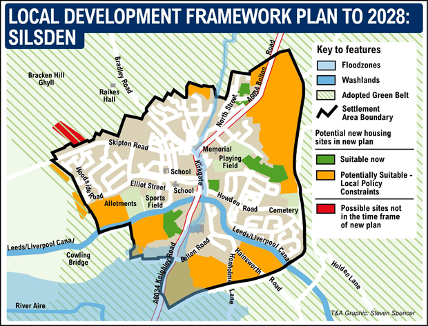
The locations which will be allocated for homes are yet to be decided but in a first step, an assessment of available land in Silsden identifies a total of 14 sites as having the potential for house-building.
Out of these, planners believe 13 plots could be delivered within the 17-year timeframe of the assessment. Eleven of these are classed as greenfield sites, one is previously developed land – or brownfield – and another is mixed.
In total Council planners believe the 71.6 hectares of land could be used for 1,592 homes, which is just short of the target in the draft LDF.
Four are classed as suitable for development now. And nine are potentially suitable given policy constraints, such as being in the green belt or safeguarded land.
Key larger sites include 20 hectares at Brown Bank Lane to the east of Silsden, which could provide space for 536 homes. The site contains farm holdings and is divided by country lanes and footpaths, as well as by Bolton Road and Brown Bank Lane. A relief road would be needed in advance of any development, but planners still believe it could be developed in the longer term.
And a neighbouring site at Bolton Road and Brown Bank Lane would need to be developed in conjunction.
The eight-hectare plot comprises uneven fields and former allotments to the east of Silsden, with residential development on its west side.
It could provide the space for 223 homes.
In addition a collection of fields at Keighley Road and Belton Road have already seen interest from developers and may be able to accommodate some development before the eastern relief road is required. Planning experts believe 344 homes could be built on the safeguarded green field site.
Furthermore a plot of nearly nine hectares at Hainsworth Road, could provide for 248 homes on fields to the south side of the Leeds-Liverpool Canal. The majority of the site is fields used for grazing and the eastern relief road would be required before the site can be developed.
The report states: “Silsden has a modest supply of land which is suitable now and could be delivered in the short term. The larger supply of land comes from sites allocated as safeguarded land in the RUDP, some which could be brought forward in the medium term, but the majority in the longer term given the off-site infrastructure requirements. Further residual yield beyond year 17 extends the potential capacity of the settlement to around 2,000 new homes.
“Silsden has limited capacity for recycling beyond year six with the large proportion of site opportunities on greenfield land. Only two of these sites are within the green belt with a small potential yield of 83 units which could suggest that there would be no requirement to look further green belt releases over and above land allocated as safe-guarded land.”
Local Conservative councillors have expressed concerns over what would effectively be an increase in the number of homes in the town of about a half.
Councillor Adrian Naylor said he wanted to see more detailed work on the infrastructure that would be needed to support such a level of development, such as education and a relief road.
Councillor Michael Kelly said he too was concerned about schooling as most of the primaries in the area were already full. He added: “Without a relief road, I can’t see how the town could possibly cope with the additional traffic that this number of homes would bring.”
THE LONG-TERM LAND STRATEGY
The Strategic Housing Land Availability Assessment (SHLAA) is a technical document which will provide a pool of sites from which to select land to be allocated for housing when preparing the Local Development Framework.
The Framework is a blueprint that will manage development and growth across the district over the next 15 years.
Consultation on it’s core strategy document, which sets out a long-term spatial vision for the district until 2028, is continuing. It sets out broad locations for development and policies that will influence the use of land and the type and scale of development permitted, as well as identifying key infrastructure requirements.
The overall Local Development Framework is expected to come into effect in 2013 with consultation over specific land allocations taking place during 2012.
Sites included in the current SHLAA may not make it into the land allocations documents and final framework. In addition further potential sites could be identified as the assessment is updated every year.

 - houses on a green field near you")


Leave a Reply
Want to join the discussion?Feel free to contribute!